Geospatial intelligence plays a crucial role in military operations, offering invaluable insights through the analysis of satellite imagery and the fusion of geospatial data.
This article delves into the significance of GIS in military strategies, highlighting its ability to map enemy activity for strategic advantage.
Additionally, it explores the efficiency of geolocation technology for precise targeting and evaluates the benefits of geospatial data fusion.
By examining these aspects, we aim to provide a thorough and technical understanding of mapping invisible threats in military contexts.
Key Takeaways
- Geospatial Intelligence (GI) plays a crucial role in military operations by providing information on enemy forces, aiding in decision-making, and enhancing situational awareness.
- Satellite imagery analysis and geospatial data fusion are important for collecting valuable insights, detecting threats, and enhancing situational awareness.
- Mapping enemy activity using geolocation technology and remote sensing techniques enables precise targeting, resource allocation, and operational planning.
- The benefits of geospatial intelligence include strategic decision-making, valuable insights for military operations, precise targeting, and overall operational effectiveness while minimizing risks.
The Significance of Geospatial Intelligence in Military Operations
The significance of geospatial intelligence in military operations lies in its ability to provide crucial information on the spatial characteristics and locations of enemy forces, aiding in strategic decision-making and enhancing situational awareness.
Geospatial analysis enables the military to understand the terrain, identify potential threats, and develop effective military strategies. By utilizing geographic information systems (GIS), military commanders can visualize data on maps, allowing them to assess vulnerabilities and plan accordingly.
Additionally, GIS allows for the integration of various data sources such as satellite imagery and ground-based sensors, facilitating a comprehensive understanding of the battlefield. This analytical approach helps optimize resource allocation and minimize risks by identifying optimal routes for troop movements or targeting enemy positions.
Geospatial intelligence thus plays a pivotal role in informing military strategy by providing accurate spatial information that contributes to successful operations.
The Importance of Satellite Imagery Analysis
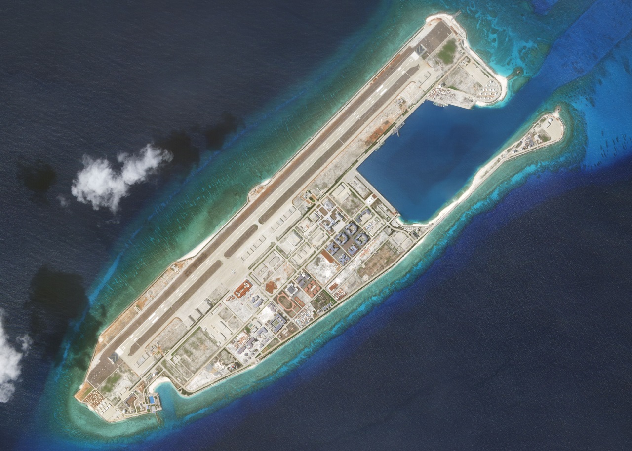
Satellite imagery analysis plays a crucial role in military operations due to its ability to provide valuable insights and intelligence. Through satellite image interpretation, important information about enemy activities can be obtained, aiding in strategic decision-making.
Remote sensing techniques allow for the collection of data from a distance, enabling military personnel to gather information about terrain, infrastructure, and potential threats without having to physically access the area. This provides a significant advantage as it minimizes risks and costs associated with ground reconnaissance missions.
Additionally, satellite imagery analysis allows for the identification of patterns and changes over time, which can help detect emerging threats or monitor ongoing activities. By fusing geospatial data from various sources, including satellites and other sensors, a more comprehensive understanding of the battlefield is achieved.
This enhances situational awareness and improves operational efficiency by enabling accurate targeting and effective resource allocation.
Mapping Enemy Activity for Strategic Advantage
By utilizing remote sensing techniques and interpreting satellite images, valuable insights can be gained regarding enemy activities, enabling strategic decision-making and enhancing situational awareness.
Mapping enemy activity for strategic advantage involves the use of advanced mapping techniques to identify and analyze patterns, trends, and potential threats posed by the enemy. This process allows military commanders to make informed decisions about troop deployments, resource allocation, and operational planning.
Geospatial data fusion plays a crucial role in this process by integrating data from various sources such as satellites, sensors, and ground-based observations to create comprehensive maps that provide a holistic view of the battlefield.
The efficiency of mapping enemy activity lies in its ability to identify key areas of interest, monitor changes over time, and predict future actions based on historical data. Geolocation technology further enhances targeting capabilities by accurately pinpointing the location of enemy assets or personnel for precise strikes or reconnaissance missions.
Overall, mapping enemy activity through geospatial intelligence is instrumental in achieving strategic objectives while minimizing risks and maximizing operational effectiveness in military operations.
Geolocation Technology for Precise Targeting
Utilizing geolocation technology allows for precise targeting of enemy assets or personnel, enabling accurate strikes and reconnaissance missions. This advanced technology provides a range of benefits in military operations, enhancing overall effectiveness and minimizing collateral damage.
Here are three key aspects highlighting the significance of geolocation technology:
Precision targeting: Geolocation technology enables pinpoint accuracy when identifying and locating enemy targets. By gathering data from various sources such as satellites, drones, and ground sensors, it creates a comprehensive picture of the target's location, movement patterns, and potential vulnerabilities.
Geolocation accuracy: The integration of satellite imagery analysis with geospatial intelligence enhances the accuracy of target identification by cross-referencing multiple data sources. This fusion ensures reliable information for decision-making processes and reduces the risk of misidentifying friendlies or civilian structures.
Tactical advantage: Precise targeting through geolocation technology provides military forces with a significant tactical advantage on the battlefield. It allows for effective planning and execution of operations while minimizing risks to friendly forces and civilians.
In conclusion, geolocation technology plays a crucial role in achieving precision targeting in military operations by ensuring accuracy and providing a tactical edge to forces on the ground.
Harnessing the Power of Geospatial Data Fusion
Geospatial data fusion enhances the effectiveness of military operations by integrating multiple sources of information for improved situational awareness and decision-making. It involves combining diverse geospatial datasets, such as satellite imagery, aerial photographs, and terrain data, to create a comprehensive picture of the operational environment. This integration allows analysts to identify patterns, detect anomalies, and gain insights that would not be possible with individual datasets alone.
One key technology used in geospatial data fusion is Geographic Information Systems (GIS). GIS enables the storage, analysis, and visualization of spatial data, facilitating the integration of different datasets into a single platform. By overlaying various layers of information on a map interface, analysts can identify relationships between different features and make informed decisions.
Another important aspect of geospatial data fusion is the use of fusion technologies. These technologies employ advanced algorithms and techniques to automatically integrate disparate datasets and extract meaningful information. They enable efficient processing and analysis of large volumes of data, saving time and resources.
In conclusion, geospatial data fusion plays a crucial role in military operations by providing a holistic view of the operational environment. It enables better understanding, planning, and execution of missions through enhanced situational awareness and informed decision-making.
Frequently Asked Questions
How does geospatial intelligence contribute to military operations beyond traditional methods?
Geospatial intelligence in unconventional warfare and geolocation in counterterrorism operations contribute to military operations beyond traditional methods by providing detailed spatial analysis and targeting capabilities, enhancing situational awareness, and improving decision-making processes.
What are the key challenges faced in satellite imagery analysis for military purposes?
Challenges in satellite imagery analysis for military purposes include limitations in resolution, weather conditions affecting visibility, and the need for real-time analysis. Overcoming these challenges is crucial for accurate mapping of enemy activity and effective geolocation for targeting.
How does mapping enemy activity using geospatial data provide strategic advantage?
Mapping enemy activity using geospatial data provides strategic advantage by allowing military forces to accurately locate and track their adversaries. This enables better planning, decision-making, and operational effectiveness in military operations.
What are the limitations of geolocation technology in targeting enemy locations precisely?
The limitations of geolocation technology in precision targeting include factors such as atmospheric interference, signal degradation, and the difficulty of accurately locating targets in densely populated or urban areas.
How does geospatial data fusion enhance the effectiveness of military operations?
Geospatial data fusion enhances military effectiveness by integrating multiple sources of geospatial information, enabling a comprehensive understanding of the battlefield. This analytical approach improves situational awareness, decision-making, and the ability to target enemy activity accurately.
 GadgetsProduct ReviewsSmart DevicesDronesVirtual DevicesPrivacy PolicyTerms And Conditions